


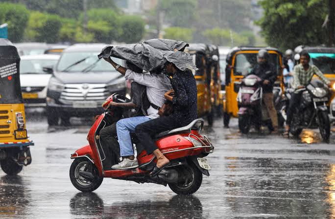
NEW DELHI, November 9, 2026 — The India Meteorological Department has forecast a spell of rain across parts of southern, eastern and northeastern India through November 13, with isolated heavy rainfall expected in Tamil Nadu, Puducherry and Karaikal, the Andaman and Nicobar Islands, and parts of the Northeast. A separate western disturbance is expected to affect the northwestern Himalayan region from November 10, bringing the possibility of rain, thunderstorms and gusty winds to Jammu and Kashmir, Ladakh and neighbouring hill states.
The forecast comes from the IMD’s All India Weather Summary and Forecast Bulletin issued at 1:45 pm IST on November 8. It is a regional outlook, not a warning that every district in the listed states will receive heavy rain. The department’s bulletin gives separate dates for each subdivision and says that a warning for a particular day is valid from 8:30 am IST that day until 8:30 am the following day. District-level warnings can change as the weather systems develop.
For residents, the immediate message is to check the warning for their district rather than assume that a state-wide forecast applies uniformly. Heavy rain at isolated places can still produce local flooding, waterlogging, landslides or transport disruption, even when most of a state receives only scattered showers. Farmers, fishers and people travelling through hill or coastal areas should use the local advisories that apply to their activity.
The November 8 bulletin forecasts isolated heavy rainfall over Tamil Nadu, Puducherry and Karaikal from November 8 to 10. Kerala and Mahe were included for November 8, while the Andaman and Nicobar Islands are expected to see isolated heavy rain from November 9 to 13. The islands are forecast to receive fairly widespread to widespread rainfall during much of the week, which is a broader distribution than an isolated heavy-rain warning.
In the Northeast, the IMD expects isolated to scattered rainfall over Arunachal Pradesh and Assam and Meghalaya from November 9 to 12, and over Nagaland, Manipur, Mizoram and Tripura from November 9 to 13. The bulletin identifies November 11 as the day when isolated heavy rainfall is likely over Nagaland, Manipur, Mizoram and Tripura. It does not describe a blanket heavy-rain warning for every northeastern state on every day.
In the northwest, the department expects rain over Jammu and Kashmir, Ladakh and adjoining areas on November 10 and 11, with another spell from November 12 to 14. Fairly widespread to widespread rainfall is forecast over the Jammu and Kashmir-Ladakh subdivision on November 12 and 13. Isolated heavy rainfall is likely there on November 12, while thunderstorms and gusty winds of 40 to 50 kilometres per hour, with stronger gusts, are possible during the period.
Himachal Pradesh is forecast to receive isolated to scattered rainfall from November 11 to 14, while Uttarakhand has rain chances on November 8 to 10 and again on November 13 and 14. Punjab is included for isolated to scattered rainfall from November 12 to 14. The bulletin does not forecast significant weather over West and Central India during the week, a useful distinction for readers who might otherwise interpret the national headline as a country-wide rain alert.
For southern India, the bulletin expects scattered rainfall over Kerala and Mahe, Lakshadweep and Tamil Nadu, Puducherry and Karaikal from November 9 to 14. Coastal Andhra Pradesh and Yanam, Rayalaseema and South Interior Karnataka are also forecast to receive isolated to scattered rain during the period. Thunderstorms, lightning and gusty winds of 30 to 40 kilometres per hour, with gusts reaching 50 kilometres per hour, are possible over parts of Andhra Pradesh, Kerala, Lakshadweep and Tamil Nadu through November 10.
The bulletin identifies several weather systems rather than a single monsoon disturbance covering the whole country. An upper-air cyclonic circulation persists over southeast Bangladesh and the surrounding region. Another circulation is present over the Comorin area, while a trough extends from that system across southern Tamil Nadu, Kerala and the southeast Arabian Sea. The IMD also says a fresh western disturbance is likely to affect the northwestern Himalayan region from November 10.
These systems influence different parts of the country. The circulation and trough over the south can support moisture convergence and rain over Tamil Nadu, Kerala and nearby areas. The system over southeast Bangladesh and the surrounding region is relevant to rainfall over parts of eastern and northeastern India. The western disturbance is a separate mid-latitude weather system that can bring cloud, precipitation and wind changes to the western Himalayas. Their timing can overlap, but they should not be described as one single storm.
The word “Northeast” can also cause confusion in weather reporting. The northeast monsoon is the seasonal rainfall pattern that is especially important for Tamil Nadu and parts of the southern peninsula during October to December. Northeast India is a geographical region covering states such as Assam, Meghalaya, Nagaland, Manipur, Mizoram, Tripura and Arunachal Pradesh. Rain in the Northeast states does not mean that the northeast monsoon has shifted there; the two descriptions refer to different things.
The southwest monsoon withdrew from the country on October 15, according to the IMD’s seasonal announcement. The northeast monsoon then became the main seasonal rain source for parts of southern India. That seasonal transition does not prevent other systems from producing rain elsewhere. A western disturbance can affect the Himalayas while a circulation near the Bay of Bengal or Bangladesh brings rain to eastern states at the same time.
Rainfall forecasts are probabilistic and regional. “Isolated” means the expected rain is limited to a small proportion of stations in the subdivision; “scattered” and “fairly widespread” describe larger coverage. A warning for isolated heavy rain can be important for a town or valley that receives a concentrated downpour, but it does not mean the entire state will be wet. The IMD’s district warning map is therefore more useful for local planning than a single national summary.
The IMD’s impact advisory lists possible waterlogging, flooding of low-lying areas, reduced visibility, disruption to road and rail traffic, and localised landslides or mudslides where heavy rain occurs. Strong winds can break branches, damage vulnerable structures and affect plantations. These are expected risks, not reports that such damage has already happened. Local authorities may issue more specific instructions if rainfall intensifies.
People travelling through hill roads in Jammu and Kashmir, Himachal Pradesh, Uttarakhand, Sikkim or Meghalaya should check the latest district and road advisories before departure. A national forecast cannot confirm whether a particular route is open. Drivers should slow down in poor visibility, avoid stopping under unstable slopes and never attempt to cross a flooded road or stream. A shallow-looking flow can conceal a damaged road surface or a stronger current.
In coastal and island areas, residents and operators should follow marine and district warnings. The November 8 bulletin did not list a fishermen warning for the days shown, but that status can change with a new bulletin. Fishers should check the latest marine forecast rather than rely on an older screenshot. Tour operators should be ready to alter trips when lightning, rough seas or heavy rain reduce visibility and access.
For households, the most useful precautions are practical: clear drains where safe, move electrical equipment away from areas that flood, keep essential medicines and documents protected, and follow local instructions if water enters a building. During thunderstorms, people should avoid open fields, water bodies and isolated trees. The IMD specifically advises taking safe shelter and unplugging electrical or electronic appliances when lightning is expected.
The bulletin also includes agricultural advice. In Tamil Nadu, farmers are advised to maintain drainage in rice, maize and casuarina fields, remove excess water and support banana plants. In Kerala, field drainage and support for banana and papaya plantations are recommended. In the Andaman and Nicobar Islands, the IMD advises harvesting mature rice and vegetables during rain-free intervals, drying produce under cover and avoiding fertiliser or pesticide application during rainfall.
These instructions are crop- and region-specific. Farmers should combine the national bulletin with the local agrometeorological advisory for their district and crop stage. Heavy rain may be beneficial for soil moisture in one field and damaging to a mature crop in another. The timing of the rain, drainage capacity and the condition of the crop determine the practical effect.
The most important dates in the current bulletin are November 9 and 10 for isolated heavy rain in Tamil Nadu, Puducherry and Karaikal, November 9 to 13 for the Andaman and Nicobar Islands, November 11 for parts of the Northeast, and November 12 for isolated heavy rain in Jammu and Kashmir and Ladakh. The forecast for November 13 and 14 includes continued rain in some hill and island subdivisions, but the warning level differs by region.
Readers should watch for the next IMD bulletin and district-level warnings, especially if the upper-air circulations strengthen or shift. A forecast issued at 1:45 pm on November 8 is a snapshot of the department’s assessment at that time; it is not a guarantee that the same warning will remain unchanged. The 8:30 am validity window also means that the daily warning period does not run from midnight to midnight.
The wider seasonal context matters, but it should not be confused with the short-term forecast. The 2026 southwest monsoon ended below the long-period average, while the northeast monsoon has become important for southern water supplies. Heavy rain in one region does not automatically compensate for a deficit elsewhere because reservoirs, rivers and farms depend on where the rain falls and when it arrives.
The IMD’s current bulletin points to a week of uneven weather: wet conditions across parts of the south and islands, rain and thunderstorms in the Northeast, and a separate spell over the western Himalayas. The practical task for residents is to follow the local warning, prepare for short-duration disruption and avoid treating a regional forecast as a nationwide alert.
Also read: IMD Declares Northeast Monsoon Onset, Warns of Heavy Rain in South India
Also read: India Records Weakest Monsoon in Over a Decade, Rainfall Ends 12.6% Below Normal


Comments (0)
Be the first to comment. Comments are published after moderation.